Browsing Tag

Trans-boundary River

Environment

What happens when the roof of the world melts?

Top 10 Gorgeous Lakes in the Himalayas

The ice that has long defined South Asia’s mountain ranges is dissolving into massive new lakes, raising the specter of catastrophic flooding.

Gokyo village, nestled beside a lake fed in part by Nepal’s Ngozumba Glacier, doesn’t face immediate danger from flooding, but other Himalayan communities are threatened by rising glacial lakes.

It’s a landscape like no other on the planet—the colossal glaciers of the Himalaya, which for millennia have been replenished by monsoons that smother the mountains in new snow each summer.

But take that same jet trip 80 years from now, and those gleaming ice giants could be gone.

Earlier this year, the International Centre for Integrated Mountain Development published the most comprehensive analysis to date of how climate change will affect the glaciers of the Himalaya, Hindu Kush, Karakoram, and Pamir mountains, which together form an arc across Afghanistan, Pakistan, China, India, Nepal, Bhutan, and Myanmar. The study warned that, depending on the rate of global warming, one-third to two-thirds of the region’s approximately 56,000 glaciers will disappear by 2100.

DANGEROUS LAKES

Scientists say the accelerated melting of Asia’s estimated 56,000 glaciers is creating hundreds of new lakes across the Himalaya and other high mountain ranges. If the natural dam holding a glacial lake in place fails, the resulting flood could wipe out communities situated in the valleys below. Engineers in Nepal are looking at ways to lower the most dangerous lakes to reduce the threat.

This is a dire prediction for some 1.9 billion South Asians, who rely on the glaciers for water—used not only for drinking and sanitation but also for agriculture, hydroelectric power, and tourism. But the survey also looked at a more immediate question: As the glaciers rapidly melt, where will all the water—more than a quadrillion gallons of it, roughly the amount contained in Lake Huron—go?

The answer is that the Himalaya, long defined by its glaciers, is rapidly becoming a mountain range defined by lakes. In fact, another study found that from 1990 to 2010, more than 900 new glacier-fed lakes were formed across Asia’s high mountain ranges. Because of the remote locations, scientists must rely on satellites to count them, and new lakes appear to be growing so quickly that it’s difficult for scientific teams to agree on the precise number.

“It’s all happening much faster than we expected it to even five or 10 years ago,” says Alton Byers, a National Geographic explorer and mountain geographer at the University of Colorado Boulder.

To understand how these lakes form, think of a glacier as an ice bulldozer slowly plowing down the side of a mountain, scraping through the earth, and leaving a ridge of debris on either side as it pushes forward. These ridges are called moraines, and as glaciers melt and retreat, water fills the gouge that remains, and the moraines serve as natural dams.

“They start as a series of meltwater ponds,” Byers explains, and “they coalesce to form a single pond, then a larger lake. And year by year they get larger and larger, until you have a lake with millions of cubic meters of water.”

And as the lake fills up, it can overspill the moraines holding it in place or, in the worst-case scenario, the moraines can give way. Scientists call such an event a glacial lake outburst flood, or GLOF, but there’s also a Sherpa word for it: chhu-gyumha, a catastrophic flood.

One of the most spectacular Himalayan GLOFs occurred in the Khumbu region of Nepal on August 4, 1985, when an ice avalanche rumbled down the Langmoche Glacier and crashed into the mile-long, pear-shaped Dig Lake.

The lake was likely less than 25 years old—a photo taken in 1961 by Swiss cartographer Edwin Schneider shows only ice and debris at the foot of Langmoche. When the avalanche hit the lake, it created a wave 13 to 20 feet high that breached the moraine and released more than 1.3 billion gallons—about the equivalent of 2,000 Olympic-size swimming pools—of water downstream.

The Sherpa who saw it described a black mass of water slowly moving down the valley, accompanied by a loud noise like many helicopters and the smell of freshly tilled earth. The flood destroyed 14 bridges, about 30 houses, and a new hydroelectric plant. According to some reports, several people were killed. By a benevolent twist of fate, the flood happened during a festival celebrating the coming harvest, so there were few local residents near the river that day, which undoubtedly saved lives.

“There have always been GLOF events,” Byers says. “But we’ve never experienced so many dangerous lakes in such a short amount of time. We know so little about them.” The Dig Lake flood focused attention on the risks posed by other lakes across the Himalaya. Chief among them were Rolpa Lake, in the Rolwaling Valley of Nepal, and Imja Lake, near the foot of Everest, directly upstream from several villages along the popular trekking route to Everest Base Camp.

In the late 1980s teams of scientists began to study those two lakes. Satellite imagery revealed that Imja Lake had formed after Dig Lake, sometime in the 1960s, and was expanding at an alarming rate. One study estimated that from 2000 to 2007, its surface area grew by nearly 24 acres.TODAY’SPOPULAR STORIES

“The challenge with glacial lakes is that the risks are constantly changing,” says Paul Mayewski, director of the Climate Change Institute at the University of Maine and leader of the 2019 National Geographic Society and Rolex expedition to study Nepal’s glaciers. For example, many moraines holding back glacial lakes are naturally reinforced with chunks of ice, which help stabilize the overall structure. If the ice melts, a once solid moraine may fail.

Other threats lurk beneath the ice. As melting occurs, large caves can be hollowed out inside a retreating glacier and can fill with water. These hidden reservoirs sometimes link via conduits in the ice to surface ponds. When an escape path for this reservoir suddenly melts out, dozens of linked ponds may drain at once, converging to create a major deluge. Though smaller and less destructive than GLOFs, this type of event—known to scientists as an englacial conduit flood—happens more frequently. Little is known about these floods. “Figuring out how water flows through glaciers is not so trivial,” Mayewski says.

But for the moment, GLOFs remain the primary worry. Byers points to the moraine at the foot of the Khumbu Glacier, where a cluster of small ponds currently sit. “That’s the next big lake,” he says, noting that the moraine towers above the trekking village of Tugla. “It’s only a matter of time before it turns into a potential risk.”

It’s difficult for scientists to assess the danger without conducting fieldwork, which often requires days of hiking to reach the remote lakes, but a 2011 study identified 42 lakes in Nepal as being at either very high risk or high risk of flooding. Across the entire Greater Himalaya region, the number could be more than a hundred.

Another nation with a long history of dealing with rising glacial lakes is Peru, a mountainous country that has lost up to 50 percent of its glacial ice in the past 30 to 40 years and has seen thousands of people killed in GLOF events. After a devastating flood from Lake Palcacocha wiped out a third of the city of Huaraz, killing some 5,000 people, Peruvians began to pioneer innovative ways to partially drain dangerous glacial lakes. Today dozens of lakes in Peru have been dammed and lowered—creating hydroelectric plants and irrigation channels in the process.

But there are major obstacles to implementing some of those solutions in Nepal. Namtso2

The big difference between Peru and the Himalaya is the logistics, explains John Reynolds, a British geo-hazards specialist who helped direct an effort that lowered Rolpa, considered by many to be the most dangerous lake in Nepal. “In Peru you could virtually drive to within a day’s walk of the lake,” he says. In Nepal, “it could take five, six days to walk to the site from the nearest roadhead.”

Rolpa Lake is so remote that heavy machinery had to be helicoptered to the lake in pieces and then reassembled. After constructing a small dam with sluice gates, engineers slowly began releasing water and drawing down the lake. “If you draw the water down too quickly, it can actually destabilize the valley flanks, particularly the lateral moraines that impounded it,” Reynolds says. Ultimately, the water level of Rolpa Lake was lowered by more than 11 feet—the first mitigation project in the Himalaya.

In 2016 the Nepalese Army participated in an emergency project that drained Imja Lake by a similar amount. Neither measure has completely relieved the respective flood risks, but both represent, along with the installation of warning systems, a positive step.

Not all glacial lakes pose an equal threat, and as scientists continue to develop new ways to study the lakes, they are learning how to assess the true level of risk each lake poses. In some instances, they’ve found that the perceived risk was overstated, including in the case of Imja Lake. “There is no actual relationship between causality of a GLOF and lake size,” Reynolds says. “What’s critical is how the lake body interacts with the dam itself.”

And it’s not just the large lakes that pose threats, says Nepali scientist Dhananjay Regmi. “We are concerned more about big lakes, but most of the disasters in recent years have been done by relatively small lakes, which we never suspected.”

Whether the lakes are small or large, there’s little doubt that conditions for setting off floods are increasing. Reynolds points out that as the permafrost begins to thaw, massive rockfalls and landslides will become more common, and if they hit vulnerable lakes, they could trigger floods similar to the 1985 Khumbu Valley flood.

“We need to be conducting integrated geo-hazard studies of these valleys,” Reynolds says. “GLOFs are just a piece of it.”

Regmi considers the growth of lakes an opportunity for development. “Every lake has its own characteristics, and each needs to be treated differently,” he explains, noting that some might be good sources of mineral water and some might be good for generating hydropower or tourism, while others might be reserved for religious purposes.

Alton Byers is optimistic about the progress already made. “It’s not just the big infrastructure projects, like lowering Imja. People who live in remote high-mountain regions are quietly going about developing their own technology to adapt.”

This story appears in the December 2019 issue of National Geographic magazine.  

Tsomgo-Photo by fashionplate

International

India, Nepal, Bhutan plan trans-border conservation area

India, Nepal and Bhutan have drafted a memorandum of understanding to create a a trans-boundary wildlife conservation ‘peace park’, Soumitra Dasgupta, inspector-general of forests (wildlife) under the environment, forest and climate change ministry told Down to Earth, the premier environment and development magazine.

“The process is in its final stage. The MoU is currently going back and forth among the countries for final changes,” he said.

The proposed Park will include biodiversity-rich landscapes in adjoining areas of the three countries, Director General of Forest Siddhanta Das told Down to Earth.

“The trans-boundary parks present a fundamental shift in which wildlife conservation is done. From a species focused approach, we are moving to a landscape based approach,” he said.

There is already one trans-boundary Protected Area in India and Bhutan, which includes the Manas landscape of Assam, and the new tripartite park will be an extension of this, Das said.

“This initiative was taken by India keeping in view the migratory wildlife species such as elephant,” Das said. 

Last month a meeting was held in Bhutan where the country shared its final views with India, which were under consideration, Das said.

The process started this year, with the idea that wildlife species, their movement and conservation should not be interrupted by political boundaries.

“This project will maintain the natural connectivity of wildlife species, undisturbed by political boundaries. The project will also help the local communities through ecotourism. It will also maintain the traditional and cultural continuity of villages that share similar traditions from time immemorial, but have been separated by the political boundary. In this sense this park will be a harbinger of peace in the area,” Dasgupta said. 

The process, although started by the MoEF&CC, has to involve the Ministry of External Affairs, given the multinational nature of the project. 

Indigenous no-state people

Hydrological Data Sharing Leads India-China Toward Better Trans-Boundary Water Cooperation

After long efforts from diplomats, experts, activists and journalists China has agreed with request from lower riparian India and Bangladesh and the the country with headwater of Brahmaputra is providing data. “It is a positive sign towards a good trans-boundary river management. Extending cooperation will definitely lead towards better cooperation among neighbouring countries. Exchange of hydrological data and weather forecasting are very important since a trans-national river belongs to many countries. Exchange of hydrological data and weather forecasting are very important since a trans-national river belongs to many countries in the region” said Chandan Kumar Duarah, a science journalist and coservation activist based in Assam, India. Not only the Brahmaputra, five rivers originating on the third-pole, the Himalayas. They are the Yangtze, the Indus, the Mekong, the Salween, and the Ganges – rank among the world’s ten most endangered rivers, he writes in Eurasia Review.

Some science and environmental journalists had opportunitities to meet Chinese journalists and experts through the different programmes. The Thirdpole and Earth Journalism Network (EJNet) gave them opportunity to interact with Chinese counterpart and we insisted Chinese experts and journalists to work with a view to have bilateral or multilateral transboundary river management pact. Ninong Ering, a member of parliament from Arunachal, was among the first to officially acknowledge that China’s early warning helped, enabling residents of the East Siang district of Arunachal to move to higher grounds.

Despite the Chinese authorities released 9020 cumec of water on the Yarlung Zangbo in Tibet, China, due to heavy rainfall in Tibet, Arunachal Pradesh and Assam had nothing to worry. For at Pashighat, in Arunachal Pradesh, the Siang is 756 metres. And at Jonai, where the river enters Assam, the width of the river is around 4 km and hence the water level of the river would rise only 30 cm there. The Union Water Resources Ministry official said Indian experts have analysed the data shared by China and came to the conclusion that the effect may not be so strong in the country even through it was an alarming situation in China.

The early warning China issued to India in August on the rising waters of its Tsangpo river – which hit its highest level in 150 years – gave the Indian authorities enough time to prepare. Thousands of people in scores of districts in Assam and Arunachal have been affected in the latest floods, but the losses are minimal in comparison with the devastation last year, which killed 130 people and left three million people stranded.

As China informed India about heavy rain in Tibet or probable flood in downstream areas, the Indian Government informed and cautioned Arunachal Government. A senior official of the Union Water Resources Ministry said it was an unprecedented situation on the Chinese side where Tsangpo broke a 150-year record with swollen waters and hence China has shared the information with India.

Anyway, Delhi should inform or involve Assam with the process equally with Arunachal Pradesh. Assam been victim of devastating floods of every year. Thousands of hectares of land has been affected by the Brahmaputra and its tributaries. Since, vast floodplains and flood effected areas belong to Assam, the state need more time to be prepared after getting the flood warning. The annual rainfall in many parts of the northeast is much higher than the southern coastal State. The densely populated floodplains of Assam thus have to worry because of changes in land use that have impacted the micro-climate adversely.

Both India and China are fast-growing economies and technological clout, and resources that can help resolve regional and global challenges. The Himalayas are now subject to accelerated glacial thaw, climatic instability, and biodiversity loss. What a difference a year can make in China-India relations. Some Indian media houses interpreted the release of water in a wrong way that might generate panic among people in the downstream. China did not respond or reacted any allegation about release of water from any dam.

As China is exploiting minerals from Yarlung Zangbor region in Tibet, India is building dams in Arunachal Pradesh to generate huge amount of hydropower. Most of river catchment is in Arunachal Pradesh, which is controlled by India but claimed by China. The region was militarised during the 1962 war, and has since been inundated by troops, roads, airports, barracks, and hospitals. These have caused deforestation, landslides, and river pollution.

All of this development and strategic activities along the border is built on the world’s third-largest ice-pack or in biodiversity hot spots. The environmental impacts of their continued entrenchment are rarely mentioned, despite the fact that they are significant and growing. The build-up of troops on the border has displaced local ethnic groups, and they have been encouraged to give up their grazing land to make way for intensive farming. Animal habitats have decreased and clashes with wildlife like tigers and snow leopards have increased. Population transfers and agricultural intensification have even heightened the risk that antibiotic-resistant super-bugs and other toxic pollutants will seep into the world’s most diffused watershed.

China’s leading English daily, The South China Morning Post writes “Just a year ago China was being blamed for a deluge in northeastern India. Now, following its tip off about the rising waters of the Tsangpo, it is being praised for minimising the damage”. Just a year ago China was being blamed for a deluge in northeastern India. Now, following its tip off about the rising waters of the Tsangpo, it is being praised for minimising the damage. Anyway, the latest fruitful data sharing opens the door of better understanding on river, dam as well as trans-boundary river management.

Early warning is must to cope with floods and people along the Brahmaputra heaved a sigh of relief as authorities in Indian states of Assam and Arunachal geared up to face any eventualities. This simply did not happen in the preceding weeks, when people in Kerala or in Nagaland and Assam were caught off guard in some of the worst man-made disasters.

This year the Meteorological Department has been warning of a deficit monsoon and there prevailed a drought-like situation in many parts of upper Assam. In the eastern part of the Golaghat district villagers resorted to the age-old practice of Bhekulir biya (marrying of frogs) to satisfy the rain gods! When conditions were such, the news of the Dhansiri river breaking the highest flood level mark at Numaligarh in Golaghat district in the early hours of Aug 2, 2018 not only confused the weather forecasting authorities, but caught almost a million people off-guard. It was simply unprecedented.

Going by the IMD’s daily district level rainfall, there has not been unprecedented rainfall in the Dhansiri River catchment in the preceding week of August 2. Rather the unprecedented flash floods in Dhansiri and the Doyang rivers that flow through Nagaland and Assam was brought by the Doyang dam situated on the River Doyang, a tributary of the River Brahmaputra, located in Wokha district of Nagaland.

The 75 MW Doyang Hydroelectric Power Project owned by North Eastern Electric Power Corporation Limited (NEEPCO)– the Central government company that owns and operates the dam wreaked havoc downstream claiming five lives as NEEPCO opened the gates of the dam.

By August 6, the Assam State Disaster Management Authority put the number of affected persons at 87,300 and 7,086 hectares of land in Golaghat district were under water. The deluge left a trail of destruction ravaging some 120 villages. Sediment and slush filled up hundreds of wetlands in the catchment.

Flood in Tran-boundary Rivers

Effected states in India has been witnessing such disasters due to most of trans-boundary rivers. The high waves of Siang (the Tsangpo or Yarlung Zangbo in China) reminded inhabitants of June, 2000 midnight when 30-feet high wave of Siang had submerged the historic township killing at least 30 people and more than 100 had gone missing. People were fast asleep and none expected flood as there was no rain. Siang is the main headwater of the Brahmaputra and it contributes at least 20-30% percent of water to the Brahmaputra. Flood and its effects are very much seen in Assam. It is the ninth largest river in the world with 19,800 cubic metre per second by discharge and the 15th longest is also one of the few rivers in the world that exhibit a tidal bore. It is said that water breaks some natural dam formed in the Himalayas and heavy water has been contributed to the Siang and flow with high waves and becomes turbulent.

It is believed that the latest turbidity of the Siang water is connected with the landslide dams that developed on the course of the river in Bayi District and rampant mining in southern China. Tensions rose when China unveiled a new mine in Lhunze, near the de facto border with India’s northeastern state of Arunachal Pradesh, east of Bhutan. The mine sits on a deposit of gold, silver, and other precious metals worth up to $60 billion.

Dams on Brahmaputra or on its tributaries either in Tibet, China or in Arunachal Pradesh, India are a matter of grave concern. The study of the December 10, 2017 satellite imagery captured by the European Space Agency’s Sentinel -2 undertaken by research scholars Chintan Sheth of the Bengaluru-based National Centre for Biological Research (NCBS) and Anirban Datta-Ray of the Ashoka Trust for Research in Ecology and the Environment (ATREE) had led to the conclusion that three dams were formed on the Yarlung Tsangpo, in the Bayi District of Nyingchi County of Tibet.

Downstream people in India are against building dams either in Chinese or Indian side. The lingering bitterness resurfaced late last year, when the more raucous sections of the Indian media began to buzz with a new China conspiracy story – the blackening of the Brahmaputra river in northeastern India. Seizing on a lawmaker’s allegation that Chinese excavations were releasing extraordinary levels of slag in the water, several media outlets saw in the discolouring a “sinister plot” from across the border. China and India’s geopolitical-resources rush threatens the safety of this entire river system. The new Lhunze mine’s position among the Brahmaputra’s headwaters is so precarious that its owner, Hua Yu Mining, was allowed to mine there. .” The mine is liable to be damaged by the region’s frequent earthquakes. It was suspected that any toxic leak from Lhunze flowed straight into the Brahmaputra.

An Indian television channel, Times Now, for example, claimed “exclusive” laboratory results to “expose” China’s evil design to “poison” and “divert” the river through mining and dam-building. China eventually refuted the media reports, saying an earthquake in Tibet that had caused large-scale landslides was responsible for the change of colour, a view echoed by the Indian government. This incident again revived demands for China to share hydrological data, with Indian lawmakers alleging that China was using its status as an upper riparian state to punish India.

New Delhi had then blamed China for breaking an earlier agreement to share hydrological data. In 2006, India and China had signed a pact under which China would share hydrological data from May 15 to October 15 every year for the Brahmaputra and Sutlej rivers, both of which originate in Tibet. The two sides renewed the agreement in memorandums of understanding signed in 2013 and in 2015. But when floods struck northeastern India last year, reports surfaced that China was not adhering to the agreement. There was speculation that China held back on the data in retaliation for the 73-day military stand-off between Indian and Chinese soldiers in Doklam near Bhutan around the same time. On its part, China said its hydrological systems were washed away by floods, as a result of which it was unable to share data.

In October-November 2017, the Siang turned dark with sediment, so much so that fish and animals were dying. As the turbidity of the river began before it entered the Indian territory, there was much speculation about Chinese activity being behind the change which prompted political leaders from the region to write to Prime Minister Narendra Modi requesting him to take up the matter with China. Experts, journalists and activists from Assam demanded for trans-national cooperation for agriculture, meteorology and flood mitigation and other purposes.

It is a wholly different story this year, which marked a high point in bilateral relations when Indian Prime Minister Narendra Modi and Chinese President Xi Jinping met in May for an “informal summit” to reset strained ties. One of the two key pacts reached at the end of the summit requires China to provide hydrological data during the flood season from May 15 to October 15 every year, and if water levels exceed mutually agreed limits during the non-flood season.

The river had turned muddy and got cleaned by April 2018. Several scientific studies in subsequent periods held an earthquake of 6.4 magnitude on the Richter scale in Tibet as a strong reason for generating enough dirt to turn the colour of the water from crystal clear to black. It is worth mentioning here that two Indian scientists working on the Brahmaputra had found three artificial, landslide-induced dams on the Yarlung Tsangpo (the Chinese name of the Siang), containing an accumulated water of around one billion cubic metres. The dams were formed following the November 17, 2017 earthquake of 6.4-magnitude that shook the Nyingchi County of Tibet.

Virulent Siang River

The Yarlung Zangbo in Arunachal Pradesh, India turned virulent with unusually high waves in last July. But the reason behind such changes in the river, which generate the major chunk of flow of the Brahmaputra, could not be determined. The water of the river had also turned blakish with high turbidity again. The Central Water Commission (CWC) maintained that since the end of the part of July, the river is behaving such a manner and also carrying turbid water. Many residents they had such waves in the rive never in their life and were not sure of the reasons behind such phenomenon. The causes of the unusual behavior could either be man-made or natural. Last year, China clarified that it would not pollute its own river, Yarlung Yarlung or Tsangpo in Tibet.

However, the high waves of the river are confined only to river’s reaches in Pasighat area of Arunachal Pradesh and no impact of this changed behaviour of the river is felt in the downstream areas of Assam. The Yarlung Zangbo takes the name of Siang as it enters India at Geling in Upper Siang district. Two other rivers– Lohit and the Dibang –join the Siang at Kobu Chapori in Assam about 30 km downstream of Pasighat, which is about 230 km from the international border to form the mighty Brahmaputra. The unusually high waves in the Siang river have created fear among the people of the two Arunachal Pradesh districts and the administration had cautioned the people to refrain from venturing into it for fishing, swimming and other activities.

Nobody could detect the cause of this and we had been very worried with the phenomenon. The Chinese side neither react nor informed about natural or unnatural activities on their side. After around one month later China informed Delhi as well as Indian Government that it had been heavy rain in Tibet or South China region and it may cause flood in downstream areas in India. The unusal waves had been seen since July, 2018.

On August 29, 2018, China alerted India of a massive cloudburst in Tibet that forced the Chinese authorities to release more water down the Brahmaputra than at any time over the last 50 years. The discharge was measured at 9,020 cubic metres per second (cumec) at 8 a.m. on August 29 and led to huge waves on the Siang in Arunachal Pradesh. Eyewitness said the wave heights at up to four metres, uncharacteristic of a river. It gave hydrological data and flood warning to the Government of India. As soon as Delhi received these information, the concerned department sent the message to State Government of Arunachl Pradesh as it is the immediate bordering state of China.

The East Siang Deputy Commissioner (DC) Tamiyo Tatak in a circular issued on 29th of August stated that the Tsangpo river has been swelling with a discharge of 9,020 cumec on August 29th morning, which broke the record of last five decades. The very next day of the flood alert, the Indian Air Force rescued 29 people stranded in an island of the Siang.

Following the report of heavy downpour in the Tsangpo basin in China, which was relayed to the Arunachal government by the Government of India, sounded alert of possible deluge by the Siang river and asked the people residing in low lying areas to refrain from venturing into the river and nearby water bodies to prevent any eventualities.

Dhemaji and Dibrugarh in Assam had sounded alert of deluge due to unprecedented rise of water in Siang River, creating panic among the people living in downstream Assam. The Dibrugarh district administration referring to a report warned the people of unprecedented rise of water level in the Brahmaputra river that might cause severe flood on the left bank. The administration in an order
issued today also asked the government officials not to leave the district headquarters and stay alert to deal with the situation.

Dhemaji district administration asked the people of riverine villages to be ready for shifting to safer places. The district administration, however, asked the people not to panic as the water resources department is keeping a vigil on the situation and any impending danger would be informed to the people in advance. Downstream, the Assam State Disaster Management Authority (ASDMA) warned the district administrations in the eastern part of the state to be on high alert on August 30.

There was nothing to panic as the Central Water Commission (CWC) had reported that the water level at the Grand Canyon of Tsangpo on August 14 was 8070 cumec and an increase should not inflict severe damages, Arunachal government officials said quoting the Chinese communication. Of course, Indian Air Force helicopters rescued 19 people stranded on an island in the Siang in the Sille-Oyan area on the morning of August 31.

As per Ravi Ranjan, superintendent engineer of the Central Water Commission (CWC) – It’s certainly a relief. “The overall flood situation in Brahmaputra and Barak basin is well within control, there is no need for any alarm, all the tributaries are running well below danger levels. Real-time information sharing by China has certainly helped prepare better.” Ninong Ering, a member of parliament from Arunachal, was among the first to officially acknowledge that China’s early warning helped, enabling residents of the East Siang district of Arunachal to move to higher grounds.

It has been a hurdle for riparian countries to mitigate water and weather related problems without a proper mechanism data sharing, weather forecasting and flood mitigation. And for the first time Indian state governments issued flood alerts based on data received from China. The Assam State Disaster Management Authority (ASDMA) agreed the alert from China but “made a difference”. ASDMA officials said although India had developed its own hi-tech satellite imaging systems which could pick up disturbances on the ground, the information was insufficient without ground data from China.


Indigenous no-state people

China’s Hydro Ambitions and the Brahmaputra

By Shreya Bhattacharya

Water covers almost 71 per cent of the earth’s surface. Yet, only three per cent of that water is potable, out of which two per cent is held in glaciers and ice caps. Even this percentage is rapidly shrinking due to growing human population, increased economic activity and rapid pollution. When increase in population is read together with demands arising from prevalent consumption patterns, it presents a bleak future scenario. It has been projected that two out of three people in the world will live in water-stressed conditions by the year 2030.1

The indispensability of water combined with scarcity creates a fertile breeding ground for potential conflict. The fact that rivers, which are an important source of fresh water, do not follow political boundaries and are more often than not trans-boundary in nature, makes the situation more complex. In fact, 46 per cent of the world’s river basins are trans-boundary in nature.2 While it is important for a nation to ensure water security for itself, yet it cannot be achieved unilaterally since rivers run through tricky terrains rife with issues of sovereignty and rights of usage and sharing with other nation states.

In this context, it becomes imperative to explore the unique advantage China has as a complete upper riparian power. China’s bid to achieve water security as well as ambitions to establish itself as a hydro-hegemon in the region is examined here, through the case of mighty Yarlung Tsangpo/Brahmaputra River, especially focusing on the implications for India.

China’s Inner Compulsions

Asia comprises 60 per cent of the world’s population (4.4 billion in 2016) and also has the highest growth rate today, with its population almost quadrupling during the 20th century.3 However, Asia’s water resources have remained constant. The two most populous countries of the world – China and India – comprising 20 and 17 per cent of the world’s population, contain only seven and four per cent of the world’s water resources, respectively.4

In 1998, then Chinese Deputy Prime Minister Wen Jiabao had stated that the very “survival of the Chinese nation” was threatened by looming water shortages.5 According to Barry Naughton, a leading expert on the Chinese economy, “China’s greatest development challenges…are in the areas where a dense population pushes up against the limits of water and what the land can provide.”6 Securing continued access, supply, and control over water resources has been a fundamental element of China’s national interest. The country is faced with some crucial internal challenges which serve to explain its drive towards achieving water security through building of dams and water diversion projects.

First, the demand for water has been increasing given its large population size concomitant with economic growth and rising standards of living. China’s per capita water supply is only 28 per cent of the world average, which is precariously below international standards for human sustainability.7

Second, China has been historically a water scarce country with uneven distribution of its water resources. The inter-regional disparity in water resources is stark. Four-fifths of the water resources in China are located in the south. The north, home to about half of the total population and the arable land, making it the centre of economic and agricultural activity in the country, contains only 20 per cent of China’s water resources. This is exacerbated by the fact that the agricultural sector, which uses 70 per cent of China’s water, and the coal industry, which utilises 20 per cent of the water resources, are both largely concentrated in the extremely water stressed northern China.8 While residents of the sparsely populated south have access to 25,000 cubic meters of freshwater per person annually, residents of the populous arid north, which includes China’s biggest and fastest growing urban areas such as Beijing and Tianjin, have less than 500 cubic metres per person annually.9 The increasing pressure on water resources, particularly in north China, is of major concern to the Chinese Government. In 2011, China’s vice-minister for water resources had declared that the country is facing an “increasingly grim” water scarcity situation.10

China’s water resource challenge consists of both quantity and quality issues. According to the Chinese Government, nearly 60 per cent of its groundwater is polluted.11 Reports from China’s ministry of environmental protection (now, ministry of ecology and environment) have indicated that less than half of China’s water can be treated to the point where it is safe for drinking, and a quarter of surface water is so polluted that they are unfit even for industrial use.12

Third, as per China’s 12th Five Year Plan (12th FYP), hydropower is being promoted as the centrepiece of China’s plan to expand renewable energy by 2020. Hydropower already accounts for six per cent of its power supply.13 China intends to triple its hydropower capacity to 300 GW. China’s 12th FYP also calls for an increase in the use of hydroelectric power, as under the 11th FYP only two-third of the hydroelectric projects could be completed. China, therefore, is increasingly damming trans-boundary rivers to achieve its hydropower targets.14

China’s 12th FYP recognises that China’s water crisis could be a choking point for its economic development.15 The Chinese Government has taken two major policy initiatives. Internally, there has been a move to improve the efficiency of water use and limit the rising demand through actions such as the “Three Red Lines” policy promulgated by the Chinese Communist Party Central Committee and the State Council. In addition, China has undertaken gigantic water diversion projects such as the South-North Water Transfer Project (SNWTP) to address its regional water distribution imbalance. The SNWTP aims to transfer some 45 billion cubic meters of water per year from central and southwest China to augment the flow of Huang He (the Yellow River) and meet the water demand in the Beijing-Tianjin region. The final cost of this project is estimated to exceed $62 billion. It would also require resettlement of thousands of people.16 The western line of this project is most controversial of the three lines as it includes building a dam on the Great Bend of Yarlung, where the river curves into the Assamese plains of India, which would entail diverting 200 billion m3 of water from Yarlung to Yellow River. However, China’s exact plans for the western line are difficult to ascertain due to conflicting information from different sources.17

Chinese Moves to Harness Brahmaputra

China’s unique position as the only country in the region which is completely upper riparian, lends it an unparalleled advantage and power to influence the flow of water to nations downstream. As an upstream state, China shares 42 major transboundary watercourses (including lakes) with its neighbouring countries. As a result, China’s international water policy is at the core of Asia’s water security.18India functions as a middle riparian state. It is a lower riparian state in relation to China, but an upper riparian state vis-a-vis Pakistan and Bangladesh.

The upper and lower riparian nations often make incompatible claims about their rights over river waters. The upper riparian nations base their claim on the principle of ‘absolute territorial sovereignty’, meaning the right to use the river waters unilaterally regardless of lower riparian concerns. This is often called the Harmon Doctrine.19 According to this doctrine, an upstream nation can freely utilise a river’s flow within its boundaries without considering the effect on a downstream state.20 The lower riparian states, on the other hand, base their claims on ‘absolute territorial integrity’ which argues that upper riparian actions should not affect the water flowing downstream.21

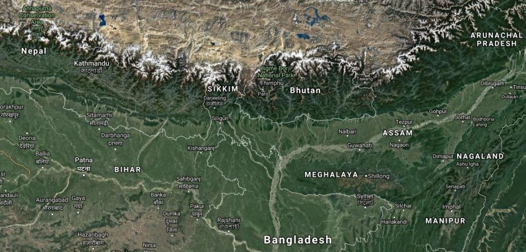
China has been seen to act in a manner typical of an upper riparian nation. Its distinctive position as a completely upper riparian nation allows it to act as a hydro-hegemon in the region. China’s hydro-hegemony is made possible by its control over Tibet. The Qinghai-Tibetan Plateau extends over a vast area spanning 2.5 million square kilometres. This Plateau, often referred to as the ‘third pole’ and ‘roof of the world’, is home to the largest fresh water reserves outside north and south poles. It is the source of some of the Asia’s most important river systems including the Indus, Ganga, Brahmaputra, Irrawady, Slaween, Mekong, Yangtze and Huang He. All these rivers are trans-boundary in nature, with the exception of Yangtze and Huang He.

As per the estimates of the Chinese ministry of water resources, the Tibet Autonomous Region (TAR) has 448.2 billion cubic metres of water, which is strategically important since it gives China an enormous edge over India in terms of control over water resources. Chinese scientists have discovered that Tibet has 40,000 times more water resources than China.22 The Chinese occupation of Tibet, wherein the most important rivers originate, de facto assures China’s hydro hegemony. The de jure control over water resources is aided by the fact that China has made huge investments in dams and has not entered into any water sharing agreement with India.23

China is no stranger to massive dam projects. The Three Gorges Dam on Yangtze River is by far the biggest in the world. However, unlike the Three Gorges Dam, where impact is restricted to areas within China, the several dam projects on Yarlung Tsangpo assumes significance since India (as well as Bangladesh further down) will be directly affected and will have to bear externalities emanating from it.24

The Yarlung Tsangpo enters India after passing the Great Bend, through Arunachal Pradesh where it is known as Siang/Dihang, then onto Assam where it is called Brahmaputra, and thereafter to Bangladesh where it is named Jamuna. China completed the Zangmu Dam (510 MW capacity) built on the upper reaches of Brahmaputra in 2010. Three more dams at Dagu (640 MW), Jiacha (320 MW) and Jeixu are at present under construction. The work on Zam hydropower station, which will be the largest dam on Brahmaputra, too commenced in 2015.25 Although the Indian allegations about Chinese dam building activities on Brahmaputra date back to more than a decade, Beijing admitted to the construction of Zangmu Dam only in 2010 and that too after a series of denials. China has not yet officially communicated anything about the construction of the other three dams – Dagu, Liacha and Jiexu – on Brahmaputra. Lack of communication by China has created an atmosphere of suspicion and mistrust in India, especially in its north-eastern region.

Chinese Unilateralism

China seems to have chosen a policy of absolute sovereignty rather than one of national integrity over shared water resources (where states have the right not to be negatively affected by activities of upper-riparian countries).26 China has built more dams on its rivers than the rest of the world combined,27 and yet has no water sharing agreement or treaty with any of its neighbours including India. For instance, China has built eight of the proposed 15 dams along the Lancang section of the Mekong River, with very little consultation with downstream countries. China’s Yunnan Provincial Government is proposing one of the world’s highest dams on the Salween River, which flows into Myanmar and Thailand. This dam would be situated in an environmentally sensitive area according to the World Wide Fund for Nature (WWF), but neither Myanmar nor Thailand have been consulted.28

China has been repeatedly invited to participate in multilateral consultations by downstream states comprising the Mekong River Commission (MRC), which it has refused to join. Chinese reluctance to participate in MRC could be attributed to growing water scarcity within the country and the possibility of similar demands by other downstream states. However, back in 2010, a severe drought in the country had pushed China to participate in MRC discussions and data sharing.29

China has also been reluctant to ratify the 1997 UN Convention on the Law of the Non-navigational Uses of International Watercourses which provides a framework for multilateral cooperation on water. Article 11 of this UN Convention mentions the need for states to share information regarding use of international water courses; Articles 21 and 23 elaborate on pollution, prevention and protection of the marine environment.30 China believes that the Convention does not adequately considers the interests of upstream states. India too has not ratified it probably because the Convention has no force over non-party countries such as China. According to Srinivas Chokkakula, Centre for Policy Research, New Delhi, the “Geopolitical and strategic imperatives do not justify a state becoming a party to the Convention unless other states with transboundary water associations also become parties.”31

China had refused to sign and ratify the Helsinki Rules too. In 1966, a codification of the principles of international law relating to transboundary water resources was completed through the International Law Association’s (ILA) Helsinki Rules on the Uses of the Waters of International Rivers. The gist of the Helsinki Rules is that each state within an international drainage basin has the right to a reasonable and equitable part of the beneficial use of the basin waters. The two basic principles can be briefly summed up as reasonable usage and an obligation to do no harm. However, the enforceability of the Helsinki Rules is undermined by the ILA’s status as an unofficial organisation. Thus, these resolutions cannot be legally binding in international law unless they are adopted in the form of a multilateral convention or followed by states as state practice.32

Implications for India

The Chinese decision to build more and more dams on Yarlung/Brahmaputra and continued evasiveness on its long-term plans, the number and kind of dams it intends to build, has been an issue of major concern for India. China, on its part, insists that the dams are and will continue to be run-of-river projects, wherein water will be returned to the river after use. As such there ought to be no fears of diversion, hoarding, and release of water later. This claim was taken with a pinch of salt by the Indian Government. In fact, in February 2014, the then External Affairs Minister Salman Khurshid admitted that the ministry of water resources has been asked to verify whether the dams built on Yarlung are run-of-river or storage dams.33

In December 2015, the External Affairs Minister Sushma Swaraj, responding to a question on steps taken by the government with regard to Chinese dam building activities on Brahmaputra, had stated that, “Government, in close cooperation with various State Governments including Government of Assam, which are users of the waters of river Brahmaputra, continues to carefully monitor the water flow in river Brahmaputra for early detection of abnormality so that corrective and preventive measures are taken to safeguard livelihood of peoples of these States of Union of India.”34

What further adds to India’s concerns is that these dams are large enough to be converted and used as storage dams, especially if the purpose is flood control and irrigation (as is the case with Zangmu Dam). In the absence of a water treaty, China depriving India of water during lean seasons becomes a possibility. According to Chandan Mahanta, who heads the Centre for Environment at the Indian Institute of Technology (IIT), Guwahati, the Chinese hydropower projects could convert Brahmaputra into a seasonal river implying water scarcity in India.35 Another risk is the release of flood waters during the monsoon season, which could inundate the already flooded Brahmaputra river basin in Assam. There is much apprehension that the Brahmaputra may lose the silt, which makes the plains in its basin fertile, because of sediment trapping in the dams.

Additionally, all hydropower projects, particularly around the Great Bend, are located in a highly volatile tectonic zone. Their proximity to known geological fault lines, where Indian Plate collides with the Eurasian Plate, makes them extremely earthquake-prone. In 2008, the Three Gorges Dam on the Yangtze River gave way under the stress of an earthquake (7.9 on the Richter scale) in the eastern rim of Tibet, resulting in loss of many lives.36 This raises serious concerns about risks posed by big dams built in such seismically sensitive areas.37

In building its dams, China has also polluted its rivers. The quality of water that flows downstream into India needs to be taken into account. The disruption of natural flood cycles of the river could also adversely affect the rich geo-environmental and bio-physical settings in India’s Northeast. These multifarious factors could also severely impinge on the economy of the region.

It is important to mention here the principle of prior appropriation, which favours neither the upstream nor the downstream State but the one that puts the water to first use, thereby protecting the right to first use of water as in the past.38 China has priority rights since it was the first to build dams on Yarlung Tsangpo. By building dams especially near the Great Bend, after which the river flows into India through Arunachal Pradesh, China could be seeking to leverage its position over the Indian state of Arunachal Pradesh.

Around the time China started working on this dam project, India too decided to commence construction of 14 hydropower projects in Arunachal Pradesh, most of which were located lower down on Brahmaputra. This might be viewed as India’s effort to establish its ‘lower riparian right’ to counter China’s first use priority rights. The idea might be to ensure a strong bargaining position to detract China from building hydel projects on the river’s upper reaches. However, except for one project, all other projects are currently stuck due to lack of necessary environmental clearance.39 The only project cleared so far is the 2000 MW Lower Subansiri hydroelectric power project, which too is languishing due to scarcity of funds.40

Some experts have pointed out that the volume of precipitation varies across the Brahmaputra sub-basin substantially. It receives primarily two types of precipitation, rainfall and snowfall. In this respect, the Tibetan part of the basin along the stretch of Yarlung, being located on the northern aspect of the Himalayas, receives much less rainfall as compared to the southern part of the basin, that is, the stretches in India and Bangladesh.41

According to a study by Chinese scholars, the total annual outflow of Yarlung from China is about 31 billion cubic metres (BCM), while the annual flow of Brahmaputra at Bahadurabad, the gauging station near the end of the sub-basin in Bangladesh, is 606 BCM. Around 80 per cent of the flows of Brahmaputra emerges within the Indian boundary.42

According to some Indian experts, the Brahmaputra gets mightier as it flows downstream because of the flow contribution of tributaries such as Dibang, Lohit and Subansiri. In terms of sediment flow, the flow volume and discharge is not sufficient to generate and transport the large sediment load that is characteristic of Brahmaputra downstream.43 Despite China having 50 per cent spatial share of this 3,000 km-long water system, low precipitation and desert conditions mean that Tibet generates only 25 per cent of its total basin discharge, while India, with 34 per cent of the basin, contributes to 39 per cent of the total discharge.44 This refutes the thinking that the flow of a river is proportional to its expanse within the country. Even then, the fact that intentional flooding and degradation of water upstream remain serious issues of concern for India, cannot be summarily dismissed.45

As of now, there is no institutionalised mechanism on water cooperation between India and China. China has signed no such treaty with India or any of its neighbours and continues to act in a unilateral manner in the region. However, in 2002, India and China had entered into a Memorandum of Understanding (MoU) wherein China agreed to share hydrological information about Yarlung Tsangpo (Brahmaputra) including its discharge at Nugesha, Yangcun and Nuxia stations from June 01 to October 15 every year. This was helpful in the formulation of flood forecasts by the Central Water Commission. When this provision ended in 2007, it was renewed for another five years. In 2006, a Joint Expert Level Mechanism was set up between the two countries in order to exchange hydrological information and ensure a smooth transmission of flood season hydrological data. In 2013, this provision was renewed with the change that 2014 onward sharing of data would take place twice a day from May 15 to October 15. However, China had refused to share hydrological data during the Doklam standoff last year.46Although hydrological data sharing resumed in 2018,47 the Doklam face-off showed how China could use water for political leverage. By refusing to share data which is crucial for flood control and planning during the monsoon period in India, China demonstrated that it is not averse to using water as a political weapon to control and force compliance on its downstream neighbours.

Any forward movement on ensuring hydro security in the Brahmaputra basin would require a long-term understanding between the two countries. India’s hydro-diplomacy thus faces the daunting challenge of engaging China in a sustained dialogue and securing a water sharing treaty that serves the interests of both the countries.

Views expressed are of the author and do not necessarily reflect the views of the IDSA or of the Government of India.

Ms Shreya Bhattacharya is Research Intern with Non Traditional Security Centre of Institute for Defence Studies and Analyses (IDSA), New Delhi.