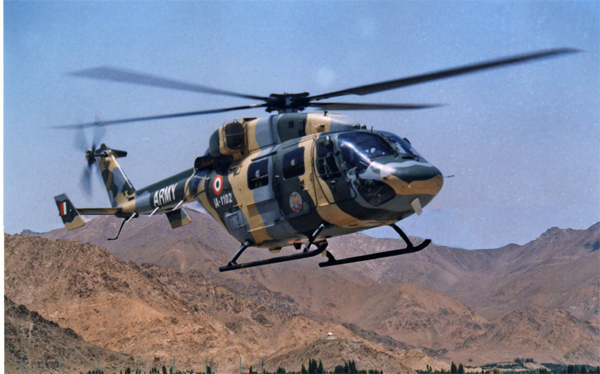
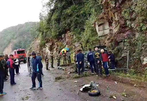
At least two pilots lost their lives after an Indian Army Cheetah helicopter crashed in Bhutan on Friday.
The Indian Army pilot who died in the crash was of Lieutenant colonel rank while the other was a Bhutanese Army pilot training with the Indian Army, news agency ANI said quoting sources in the Indian Army.
Bhutan: An Indian Army Cheetah helicopter crashed in Bhutan today, both pilots lost their lives. It was enroute from Khirmu(Arunanchal) to Yongfulla(Bhutan) on duty. The 2 pilots were-an Indian Army pilot of Lieutenant colonel rank&a Bhutanese Army pilot training with Indian Army
The pilots have been identified as – Lieutenant Colonel Rajneesh Parmar (Indian Army) and Captain Kalzang Wangdi (Royal Bhutan Army).
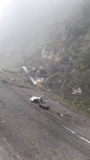
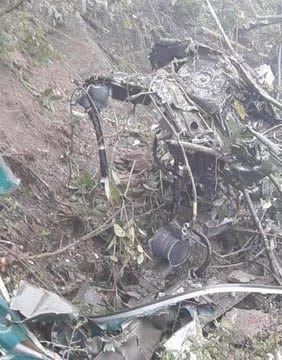
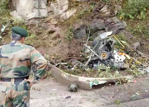
Below are some of the pictures of the wreckage of Cheetah helicopter that crashed in Bhutan today:
Indian Army spokesperson Col Aman Anand said that the chopper crashed at around 1 pm near Khentongmani, Yonphullla in Bhutan due to foggy weather. The chopper went out of the radio and visual contact soon after 1 pm. He added that a ground search and rescue operation was launched from Yongfulla and the wreckage was spotted.
Indian Army Spokesperson, Col Aman Anand: An Indian Army Helicopter crashed at 1 pm near Yongphulla in Bhutan. Helicopter went out of radio and visual contact soon after 1 pm. It was enroute from Khirmu (Arunanchal Pradesh) to Yongfulla on duty. (file pic)
“The chopper was on its way from Khirmu (Arunanchal) to Yongfulla on duty. Ground SAR was launched immediately from Yongfulla,” he added.
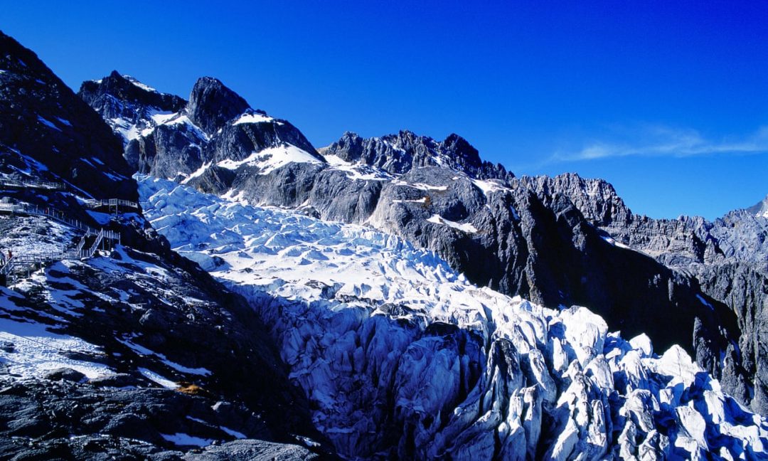
Many moons ago in Tibet, the Second Buddha transformed a fierce nyen (a malevolent mountain demon) into a neri (the holiest protective warrior god) called Khawa Karpo, who took up residence in the sacred mountain bearing his name. Khawa Karpo is the tallest of the Meili mountain range, piercing the sky at 6,740 metres (22,112ft) above sea level. Local Tibetan communities believe that conquering Khawa Karpo is an act of sacrilege and would cause the deity to abandon his mountain home. Nevertheless, there have been several failed attempts by outsiders – the best known by an international team of 17, all of whom died in an avalanche during their ascent on 3 January 1991. After much local petitioning, in 2001 Beijing passed a law banning mountaineering there.Advertisement
However, Khawa Karpo continues to be affronted more insidiously. Over the past two decades, the Mingyong glacier at the foot of the mountain has dramatically receded. Villagers blame disrespectful human behaviour, including an inadequacy of prayer, greater material greed and an increase in pollution from tourism. People have started to avoid eating garlic and onions, burning meat, breaking vows or fighting for fear of unleashing the wrath of the deity. Mingyong is one of the world’s fastest shrinking glaciers, but locals cannot believe it will die because their own existence is intertwined with it. Yet its disappearance is almost inevitable.
Khawa Karpo lies at the world’s “third pole”. This is how glaciologists refer to the Tibetan plateau, home to the vast Hindu Kush-Himalaya ice sheet, because it contains the largest amount of snow and ice after the Arctic and Antarctic – the Chinese glaciers alone account for an estimated 14.5% of the global total. However, a quarter of its ice has been lost since 1970. This month, in a long-awaited special report on the cryosphere by the Intergovernmental Panel on Climate Change (IPCC), scientists will warn that up to two-thirds of the region’s remaining glaciers are on track to disappear by the end of the century. It is expected a third of the ice will be lost in that time even if the internationally agreed target of limiting global warming by 1.5C above pre-industrial levels is adhered to.
Whether we are Buddhists or not, our lives affect, and are affected by, these tropical glaciers that span eight countries. This frozen “water tower of Asia” is the source of 10 of the world’s largest rivers, including the Ganges, Brahmaputra, Yellow, Mekong and Indus, whose flows support at least 1.6 billion people directly – in drinking water, agriculture, hydropower and livelihoods – and many more indirectly, in buying a T-shirt made from cotton grown in China, for example, or rice from India.Advertisement
Joseph Shea, a glaciologist at the University of Northern British Columbia, calls the loss “depressing and fear-inducing. It changes the nature of the mountains in a very visible and profound way.”
Yet the fast-changing conditions at the third pole have not received the same attention as those at the north and south poles. The IPCC’s fourth assessment report in 2007 contained the erroneous prediction that all Himalayan glaciers would be gone by 2035. This statement turned out to have been based on anecdote rather than scientific evidence and, perhaps out of embarrassment, the third pole has been given less attention in subsequent IPCC reports.
There is also a dearth of research compared to the other poles, and what hydrological data exists has been jealously guarded by the Indian government and other interested parties. The Tibetan plateau is a vast and impractical place for glaciologists to work in and confounding factors make measurements hard to obtain. Scientists are forbidden by locals, for instance, to step out on to the Mingyong glacier, meaning they have had to use repeat photography to measure the ice retreat.
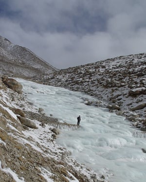
In the face of these problems, satellites have proved invaluable, allowing scientists to watch glacial shrinkage in real time. This summer, Columbia University researchers also used declassified spy-satellite images from the cold war to show that third pole ice loss has accelerated over this century and is now roughly double the melt rate of 1975 to 2000, when temperatures were on average 1C lower. Glaciers in the region are currently losing about half a vertical metre of ice per year because of anthropogenic global heating, the researchers concluded. Glacial melt here carries significant risk of death and injury – far more than in the sparsely populated Arctic and Antarctic – from glacial lake outbursts (when a lake forms and suddenly spills over its banks in a devastating flood) and landslides caused by destabilised rock. Whole villages have been washed away and these events are becoming increasingly regular, even if monitoring and rescue systems have improved. Satellite data shows that numbers and sizes of such risky lakes in the region are growing. Last October and November, on three separate occasions, debris blocked the flow of the Yarlung Tsangpo in Tibet, threatening India and Bangladesh downstream with flooding and causing thousands to be evacuated.
An artificial glacier in Ladakh, created by engineer and farmer Chewang Norphel. Photograph: Chewang Norphel
One reason for the rapid ice loss is that the Tibetan plateau, like the other two poles, is warming at a rate up to three times as fast as the global average, by 0.3C per decade. In the case of the third pole, this is because of its elevation, which means it absorbs energy from rising, warm, moisture-laden air. Even if average global temperatures stay below 1.5C, the region will experience more than 2C of warming; if emissions are not reduced, the rise will be 5C, according to a report released earlier this year by more than 200 scientists for the Kathmandu-based International Centre for Integrated Mountain Development (ICIMOD). Winter snowfall is already decreasing and there are, on average, four fewer cold nights and seven more warm nights per year than 40 years ago. Models also indicate a strengthening of the south-east monsoon, with heavy and unpredictable downpours. “This is the climate crisis you haven’t heard of,” said ICIMOD’s chief scientist, Philippus Wester.
There is another culprit besides our CO2 emissions in this warming story, and it’s all too evident on the dirty surface of the Mingyong glacier: black carbon, or soot. A 2013 study found that black carbon is responsible for 1.1 watts per square metre of the Earth’s surface of extra energy being stored in the atmosphere (CO2 is responsible for an estimated 1.56 watts per square metre). Black carbon has multiple climate effects, changing clouds and monsoon circulation as well as accelerating ice melt. Air pollution from the Indo-Gangetic Plains – one of the world’s most polluted regions – deposits this black dust on glaciers, darkening their surface and hastening melt. While soot landing on dark rock has little effect on its temperature, snow and glaciers are particularly vulnerable because they are so white and reflective. As glaciers melt, the surrounding rock crumbles in landslides, covering the ice with dark material that speeds melt in a runaway cycle. The Everest base camp, for instance, at 5,300 metres, is now rubble and debris as the Khumbu glacier has retreated to the icefall.
The immense upland of the third pole is one of the most ecologically diverse and vulnerable regions on Earth. People have only attempted to conquer these mountains in the last century, yet in that time humans have subdued the glaciers and changed the face of this wilderness with pollution and other activities. Researchers are now beginning to understand the scale of human effects on the region – some have experienced it directly: many of the 300 IPCC cryosphere report authors meeting in the Nepalese capital in July were forced to take shelter or divert to other airports because of a freak monsoon.
But aAside from such inconveniences, what do these changes mean for the 240 million people living in the mountains? Well, in many areas, it has been welcomed. Warmer, more pleasant winters have made life easier. The higher temperatures have boosted agriculture – people can grow a greater variety of crops and benefit from more than one harvest per year, and that improves livelihoods. This may be responsible for the so-called Karakoram anomaly, in which a few glaciers in the Pakistani Karakoram range are advancing in opposition to the general trend. Climatologists believe that the sudden and massive growth of irrigated agriculture in the local area, coupled with unusual topographical features, has produced an increase in snowfall on the glaciers which currently more than compensates for their melting.Advertisement
Elsewhere, any increase in precipitation is not enough to counter the rate of ice melt and places that are wholly reliant on meltwater for irrigation are feeling the effects soonest. “Springs have dried drastically in the past 10 years without meltwater and because infrastructure has cut off discharge,” says Aditi Mukherji, one of the authors of the IPCC report.
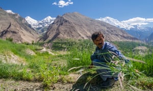
A man tends a vegetable plot in the Karakoram range. Photograph: Luis Dafos/Getty Images
Known as high-altitude deserts, places such as Ladakh in north-eastern India and parts of Tibet have already lost many of their lower-altitude glaciers and with them their seasonal irrigation flows, which is affecting agriculture and electricity production from hydroelectric dams. In some places, communities are trying to geoengineer artificial glaciers that divert runoff from higher glaciers towards shaded, protected locations where it can freeze over winter to provide meltwater for irrigation in the spring.
Only a few of the major Asian rivers are heavily reliant on glacial runoff – the Yangtze and Yellow rivers are showing reduced water levels because of diminished meltwater and the Indus (40% glacier-fed) and Yarkand (60% glacier-fed) are particularly vulnerable. So although mountain communities are suffering from glacial disappearance, those downstream are currently less affected because rainfall makes a much larger contribution to rivers such as the Ganges and Mekong as they descend into populated basins. Upstream-downstream conflict over extractions, dam-building and diversions has so far largely been averted through water-sharing treaties between nations, but as the climate becomes less predictable and scarcity increases, the risk of unrest within – let alone between – nations grows.
Towards the end of this century, pre-monsoon water-flow levels in all these rivers will drastically reduce without glacier buffers, affecting agricultural output as well as hydropower generation, and these stresses will be compounded by an increase in the number and severity of devastating flash floods. “The impact on local water resources will be huge, especially in the Indus Valley. We expect to see migration out of dry, high-altitude areas first but populations across the region will be affected,” says Shea, also an author on the ICIMOD report.
As the third pole’s vast frozen reserves of fresh water make their way down to the oceans, they are contributing to sea-level rise that is already making life difficult in the heavily populated low-lying deltas and bays of Asia, from Bangladesh to Vietnam. What is more, they are releasing dangerous pollutants. Glaciers are time capsules, built snowflake by snowflake from the skies of the past and, as they melt, they deliver back into circulation the constituents of that archived air. Dangerous pesticides such as DDT (widely used for three decades before being banned in 1972) and perfluoroalkyl acids are now being washed downstream in meltwater and accumulating in sediments and in the food chain.
Ultimately the future of this vast region, its people, ice sheets and arteries depends – just as Khawa Karpo’s devotees believe – on us: on reducing our emissions of greenhouse gases and other pollutants. As Mukherji says, many of the glaciers that haven’t yet melted have effectively “disappeared because in the dense air pollution, you can no longer see them”.
To evolve a consolidated strategy for management of its north-east region’ water resources, India will shortly set up a North East Water Management Authority (NEWMA), according to government officials. The authority is being set up on the recommendations of a high level committee headed by NITI Aayog vice-chairman Rajiv Kumar, in the backdrop of China’s ambitious $62 billion south-north water diversion scheme.
NEWMA will be the apex authority for developing all projects related to hydropower, agriculture, bio-diversity conservation, flood control, inland water transport, forestry, fishery and eco-tourism in the region. It will also help spearhead India’s efforts to establish prior user rights on waters from the rivers that originate in China.
The committee was set up in October 2017 with the aim of helping India’s flood-ravaged north-east. Its mandate was to facilitate optimising benefits of appropriate water management and NITI Aayog, the federal policy think tank headed the efforts. This assumes significance as India has been pushing to establish prior user rights on rivers that originate in China in an effort to fast-track projects in the northeast. Also, Japan has joined hands with India to aggressively develop infrastructure projects in the region with an India-Japan Coordination Forum for Development of North East been set up.
“The committee’s report has been finalised and its is on that basis that a structured approach is being considered. The main purpose is to take care of power generation, irrigation, flood control, soil erosion among all other measures,” said a senior Indian government official requesting anonymity.
“The report has been submitted some months back. We are going ahead with constituting the NEWMA. The vice chairman of Niti Aayog chaired this. Niti Aayog has been at the forefront of this,” said a second Indian government official who also did not want to be named.
With one of the focus areas being hydropower, the strategy will also help establish first-user rights to the waters of the Brahmaputra. The total hydropower generation potential of India’s North-Eastern states, and Bhutan, is about 58,000MW. Of this Arunachal Pradesh alone accounts for 50,328MW, the highest in India.
Queries emailed to NITI Aayog vice-chairman Kumar and a Niti Aayog spokesperson on Thursday morning wasn’t immediately answered.
To have all states on board to work in tandem for implementing a concerted strategy, the chief secretaries of all the eight states of the region were included in the committee. The committee also comprises secretaries from the ministries of development of north-eastern region (DoNER), power, water resources, river development and Ganga rejuvenation, National Disaster Management Authority, departments of border management and space.
Developing hydropower projects has been a recurring theme of India’s strategic play in the border areas, specifically with China and Pakistan in mind. A case in point being the 330 MW Kishanganga hydro power project in Jammu and Kashmir that was commissioned last May on the river Kishanganga, a tributary of Jhelum. While Pakistan had challenged the project under the Indus Waters Treaty of 1960, the International Court of Arbitration at The Hague ruled in India’s favour in 2013.
India is now also looking at expediting strategically important hydropower projects in Jammu and Kashmir to fully utilize its share of water under the Indus Waters Treaty. State run NHPC Ltd plans to construct these hydropower projects in the context of China developing the controversial China-Pakistan Economic Corridor (CPEC).
The committee’s terms of reference against the backdrop of floods that have brought life to a standstill in Assam, Arunachal Pradesh and Manipur also included identification of gaps in the existing mechanisms and arrangements for water resource management, and suggesting policy interventions.
Mint reported on 30 August that 103 private hydropower projects in Arunachal Pradesh with a total capacity of 35 gigawatts (GW) still to take off despite the government’s Act East policy. This comes against the backdrop of growing concerns on the delay in India’s plans to generate power from rivers originating from neighbouring China. A delay in building hydropower projects on rivers originating in China will affect India’s strategy of establishing its prior-use claim over the waters, according to international law.
China on its part is going ahead on its south-north water diversion scheme of the rivers that feed downstream into the Brahmaputra, known in China as the Yarlung Tsangpo. Of the 2,880km of the Brahmaputra’s length, 1,625km is in Tibet, 918km in India, and 337km in Bangladesh. Of the eight river basins in Arunachal Pradesh, Subansiri, Lohit and Siang are of strategic importance, as they are closer to the border with China.
On 07 September 2012, our former President Late Dr APJ Abdul Kalam made a prophetic statement while speaking at St Thomas College, Pala saying, “Future wars will be over water”. While referring to this, one is not talking about the present Cauvery Water Crisis between Karnataka and Tamilnadu. There has been a lot of discomfort in the Indian strategic circles that China may choke the water of Brahmaputra, known as Yarlong Zangbo in China, either by constructing dams on it or by diverting her waters, thereby affecting the availability of water for the middle riparian state of India and the lower riparian state of Bangladesh. China has not signed a water sharing treaty with any country and that increases the uncertainties about her behaviour over water.
All strategists studying China know about her penchant for building her asymmetric capabilities. Colonel Qiao Liang and Colonel Wang Xiangsui, two Chinese Colonels who wrote a book titled ‘Unrestricted Warfare’ in which they described all types of asymmetric capabilities that China may use against her adversaries. They mention that modern technology can be employed to influence the natural state of rivers under the subject of Ecological Warfare. Such writings by Chinese themselves have added to the concerns about China’s intentions with respect to the dams that she is building on Brahmaputra.
For long, there has been an uneasy expectation that China will divert the waters of Brahmaputra from the Great Bend (that is created by the Yarlong Zangbo going around the massive Namcha Barwa Feature), to get water to the parched Northern parts of China (Refer Map1).
Map 1.
More worrying than China’s construction of Hydro power dams on the Brahmaputra is the proposed northward diversion of its waters at the Great Bend. If this diversion takes place, it may result in a significant drop in the river’s water level as it enters India. Should that happen, then it will have a serious impact on agriculture and fishing in the downstream areas as the salinity of water will increase. Some analysts predict the extreme view that “water wars” could break out between India and China while a few others reject such predictions of a Sino-Indian war over the Brahmaputra.
However, Jiao Yong, the then Chinese Vice Minister for Water Resources is on record saying that, “The Yarlung Zangbo river flows across China’s Qinghai Tibet Plateau. Many Chinese citizens have been calling for greater usage of this river. However, considering the technical difficulties, actual need of diversion, possible impact on the environment and state-to-state relations, the Chinese government has no plans to conduct any diversification project in this river”. He said this in response to a query during a press conference in Beijing on 13 October 2011.
Many a time the Brahmaputra water diversion project is also confused with the three water diversion projects that China is undertaking (Refer Map 2).
Map 2.
All these are part of the river linking projects that China thought of during Mao Zedong’s regime in the 1950s. The $62 billion South-North Water Transfer Project aims to divert 44.8 billion cubic meters of water per year from the Yangtze River in Southern China to the Yellow River Basin in arid Northern China. The Eastern and Central Diversions are already functioning. The project suffers from cost over runs and environmental problems.
The problem of water issues gets compounded if it is taken in conjunction with the number of dams that China is constructing on the Yarlung Zangbo river. There have been divergent views on the dams on Brahmaputra. As per Romesh Bhattacharji, a former Indian bureaucrat “India has nothing to be worried about”. The Zangmu hydropower station is a run-of-the-river project and Brahmaputra’s waters will continue to flow to India as before. He also says, “Brahmaputra gets most of its waters after entering India.” Dr Jabin Jacob, Assistant Director of Institute of China Studies echoes his view. He says, “Brahmaputra gets most of its waters after entering India.” It is the Brahmaputra’s tributaries in India and the heavy rainfall here that provides roughly 70 percent of the water volume of the Brahmaputra River. However, some analysts warn that even though the Brahmaputra gathers the bulk of its volume in India, 30 percent of the river’s flow is a large enough component to have adverse effects and even as low as a 10 percent diversion could have serious consequences for downstream areas.
In October 2015, the Zangmu Hydroelectric Project was commissioned on the Yarlung Zangbo, which flows into India as the Siang River and then becomes the Brahmaputra. Zangmu is located approximately 250 Kms West of the Great Bend. Three more hydroelectric projects, Dagu, Jiexu and Jiacha are being constructed on the Yarlung Zangbo (Refer Map3).
Map 3.
China’s Xinhua reported on 30 September 2016 that China has blocked the Xiabuqu river, a tributary of the Yarlung Zangbo, at Xigatse in the Tibetan Autonomous Region to build the Lalho hydroelectric project. (Refer Map4) This project started in June 2014 and is expected to finish in 2019. Therefore, blocking of the this river for the project is not related to the present crisis with Pakistan. On 08 October 2016, China’s Foreign Ministry assured India that this dam will have no impact on down stream flows as it can hold only 0.02% of the rivers average run off. It further said that India is monitoring the volumes of the river and is provided the hydrological data from 15 May to 15 October every year.
Map 4.
The jury is still out on whether China will divert the Brahmaputra’s water to her parched North. Even when China was constructing the Three Gorges Dam and the Qinghai – Tibet Railway doubts were being raised about the technical problems that these projects would face. Not only did she overcome the technical problems but she also finished these projects one year ahead of time. Therefore, prudence demands that we plan that China may sometime in future go for diversion of water from Brahmaputra. Water and land issues are greatly influenced by emotions. Since China is an upper riparian state, we should make constant efforts to convince China that the negative results of the water diversion projects will far outweigh the advantages. As far as the run of the river projects are concerned, since they will not materially affect the flow of water on the Brahmaputra, one need not be very vociferous about them. It goes without saying that the areas of Great Bend and the areas where the dams are coming up need to be constantly monitored. The dam on the Xiabuqu River for the Lalho Hydro Electric Project is located on a tributary that drains into Yarlung Zangbo. How much it will affect the flow of water in Brahmaputra needs to studied and should it be significant, our concerns should be discussed with China. It should be understood that the Lalho Project is in China’s territory and she has no treaty obligation with us. Reasoning with China may or may not work. But it seems to be the better choice available with India because the other path of confrontation and conflict will not be fruitful to India till at least the middle of the next decade.
As a repartee, in a bid to exploit the enormous hydropower potential of the Brahmaputra, India is also planning the construction of a number of mega dams and micro hydel projects in Arunachal Pradesh. (Refer Map 5)
Map 5.
In India also, the Interlinking of River (ILR) programme is of national importance and has been taken up on high Priority. Hon’ble Minister for Water Resources, RD & GR is monitoring the progress of ILR on weekly basis. The mission of this programme is to ensure greater equity in the distribution of water by enhancing the availability of water in drought prone and rain fed area. The National Perspective Plan (NPP) prepared by Ministry of Water Resources, has already identified 14 links under Himalayan Rivers Component and 16 links under Peninsular Rivers Component for inter basin transfer of water based on field surveys and investigation and detailed studies. Out of these, Feasibility Reports of 14 links under Peninsular Component and 2 links (Indian portion) under Himalayan Component have been prepared.
It is easily seen that countries like India and China carry out such projects based on the necessity. We need to see China’s handling of the Brahmaputra issue also in that light. There are lurking shadows in the Brahmaputra River Issue but India should be confident of herself in handling them with China.
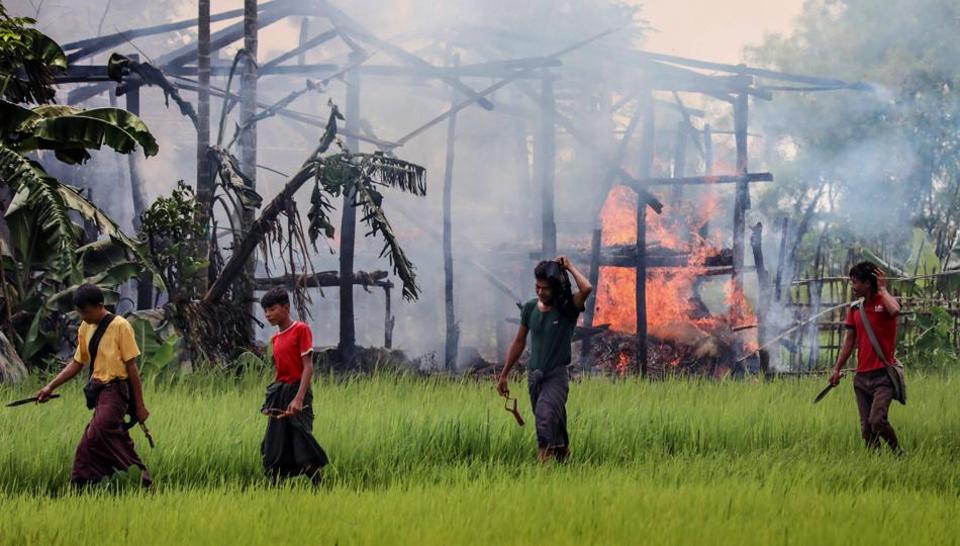
A special U.N. fact-finding mission has urged that Myanmar be held responsible in international legal forums for alleged genocide against its Muslim Rohingya minority.
The Independent International Fact-Finding Mission on Myanmar said in a report Monday wrapping up two years of documentation of human rights violations by security forces that counterinsurgency operations against Rohngya in 2017 included “genocidal acts.”
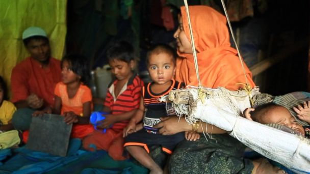
It said the operations killed thousands of people and caused more than 740,000 Rohingya to flee to Bangladesh.
The mission said the threat of genocide continues for an estimated 600,000 Rohingya still inside Myanmar living in “deplorable” conditions and facing persecution. The situation makes the repatriation of Rohingya refugees impossible, it said.
“The threat of genocide continues for the remaining Rohingya,” mission head Marzuki Darusman said in a statement.
The report summarized and updated six others previously issued by the mission that detailed accounts of arbitrary detention, torture and inhuman treatment, rape and other forms of sexual violence, extrajudicial, summary or arbitrary killings, enforced disappearances, forced displacement and unlawful destruction of property.
It is to be presented Tuesday in Geneva to the Human Rights Council, which established the mission in 2017.
Muslim Rohingya face heavy discrimination in Buddhist-dominated Myanmar, where they are regarded as having illegally immigrated from Bangladesh, even though many families have lived in Myanmar for generations. Most are denied citizenship and basic civil rights.
The homes of many were destroyed during the counterinsurgency operation and there is little sign that refugees will not face the same discrimination if they return.
A plan to repatriate an initial group last month collapsed when no one wanted to be taken back.
The U.N. mission has focused on the Rohingya in Rakhine state but also covered actions by Myanmar’s military — known as the Tatmadaw — toward other minorities in Rakhine, Chin, Shan, Kachin and Karen states.
It said those groups also experienced “marginalization, discrimination and brutality” at the military’s hands.
“Shedding light on the grave human rights violations that occurred and still are occurring in Myanmar is very important but not sufficient,” said Radhika Coomaraswamy, a Sri Lankan lawyer who was one of the mission’s three international experts.
“Accountability is important not only to victims but also to uphold the rule of law. It is also important to prevent repetition of the Tatmadaw’s past conduct and prevent future violations,” he said in a statement.
According to the mission, it has a confidential list of more than 100 people suspected of involvement in genocide, crimes against humanity and war crimes, in addition to six generals whom it already named a year ago.
Citing the problem of military impunity under Myanmar’s justice system, the report called for accountability to be upheld by an international judicial process.
This could include having the U.N. Security Council refer the matter to the International Criminal Court, establishing an ad-hoc tribunal on Myanmar, such as was held for crimes in the former Yugoslavia or Rwanda, or invoking the 1948 Genocide Convention — which Myanmar has ratified — to ask the International Court of Justice to rule on compensation and reparations for the Rohingya.
With its work concluded, the mission has handed over the information it collected to another specially established U.N. group, the new Independent Investigative Mechanism for Myanmar.
The new group’s mandate is to “build on this evidence and conduct its own investigations to support prosecutions in national, regional and international courts of perpetrators of atrocities in Myanmar.”
Myanmar’s government and military have consistently denied violating human rights and said its operations in Rakhine were justified in response to attacks by Rohingya insurgents.
A narrow road bifurcates the hyper-green paddy fields of Webi village in Middle Andaman, in the Andaman and Nicobar Islands. A clear stream flows around the Webi, home to the Karen community, brought to these shores from Myanmar 93 years ago.
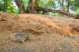
At dusk, as fading sunlight paints the surrounding hills in silhouette, the calls of cicadas, crickets and frogs rise in crescendo. In the cacophonic stillness, a centipede winds its way across the empty weathered road. And then, in the blink of an eye, it’s gone, swallowed whole by a recent migrant to the island — the Indian bullfrog (Hoplobatrachus tigerinus).
Barely 10 cm long, this particular specimen is small. But the larger ones weigh at least half a kilo. The golden stripe on their backs and the glitter around their throats shine in the diffused light of a mobile phone. Less than two feet from the centipede-eater sits another frog. Next to that, one more, and another, and another… scores of frogs in varied sizes, basking in the warmth of the asphalt. Every now and then, one of them leaps toward the murky waters of the paddy fields. There is nothing frog-like about the deep, guttural croaks of these prolific breeders. Rather, they sound more like a bull with a sore throat.
“It wasn’t here even five years ago. Now they’ve taken over the village,” says Nau Thaw Raytoo, a mother of four, who lives in a concrete-bamboo house with her children, their wives, and her six grandchildren. Her broken Hindi shifts to fluent, high-pitched Karen when instructing raucous kids.
The bullfrog is only the latest entrant in the Andamans’ 150-year-old history of invasives. Picture shows Gannatabla village at Diglipur in North Andaman. | Photo Credit: K. Murali KumarMORE-INGround Zero
The Indian bull frog, a recent arrival from the mainland, is steadily occupying the islands’ ecosystem and threatening the local economy. Mohit M. Rao reports on the bizarre man-frog conflict brewing in the islands
Barely 10 cm long, this particular specimen is small. But the larger ones weigh at least half a kilo. The golden stripe on their backs and the glitter around their throats shine in the diffused light of a mobile phone. Less than two feet from the centipede-eater sits another frog. Next to that, one more, and another, and another… scores of frogs in varied sizes, basking in the warmth of the asphalt. Every now and then, one of them leaps toward the murky waters of the paddy fields. There is nothing frog-like about the deep, guttural croaks of these prolific breeders. Rather, they sound more like a bull with a sore throat.
“It wasn’t here even five years ago. Now they’ve taken over the village,” says Nau Thaw Raytoo, a mother of four, who lives in a concrete-bamboo house with her children, their wives, and her six grandchildren. Her broken Hindi shifts to fluent, high-pitched Karen when instructing raucous kids.
Webi is just among the scores of villages in the islands where the amphibian has arrived in hordes. An unusual man-frog conflict is brewing. The voracious animal gulps down anything that would fit in its jaws: centipedes, leeches, native frogs, lizards, small snakes, and even chicks and ducklings, which are an important source of food for the islanders.
“I’ve seen them eat chicks, swallowing the head whole,” says Raytoo, adding that of the 15 chicks hatched in the family’s chicken coop this year, only three have survived. Balakishore, whose father is Ranchi (an overarching term for Jharkhand tribals who were settled here to clear the forests decades ago) and mother is Karen, has lost 50 ducklings to the frogs. When grown, each duck would have fetched at least ₹300 in the local market.
In the villages carved out of the virgin Andaman forests, the amphibian invader has evoked both surprise (“where did they come from?”) — and anxiety (“when will they go away?”). The bullfrog, found widely in mainland India and protected under Schedule IV of the Indian Wildlife Act 1972, is making the most of a free run that it’s enjoying in the erstwhile penal colony.
In the Andaman Islands, it can rain eight months of the year. The first rains in May are the signal for the bullfrogs to come out of the streams and agricultural ponds that have become their shelters. They breed by the hundreds, with each female able to lay between 3,500 and 20,000 eggs. Not all survive, but enough live to breed again, ensuring that the horde extends their range. With an average life span of seven years, and time to sexual maturity of 10-12 months, their population can dramatically shoot up in a very short time, which is precisely what happened once they landed in the islands.
“This is an invasion,” says Nitya Mohanty, a doctoral student at the Centre for Invasion Biology at Stellenbosch University (South Africa). His research, done with the Andaman and Nicobar Environment Team, has been on invasive species — first on the chitals (spotted deer) that have established their herds in the Andamans, and now on the bullfrog invasion.
So far, the bullfrog has been found in six out of the eight major inhabited islands. In 2017, it was even found in Little Andaman, which is separated from the Greater Andaman Islands by more than 55 km of sea. “This kind of incursion into remote islands is not naturally possible in such a short time,” says Mohanty.
The frog has acquired many names in the course of its journey through multi-cultural settlements of the island: shona beng (‘Golden frog’, for the prominent golden stripe) among the Bengali settlers; haramendak (‘Green frog’, for its olive-green skin) in Ranchi villages, where you could hear Oraon, Sadri or Munda being spoken; and dey-phala (‘Green frog”) in villages where the 2,500-odd Karen community stays. Whatever the name or language, the narrative of economic loss and ecological threat is a constant.
How they spread
Mohanty’s team sought to define the contours of this “invasion” through interviews with locals. As early as 2001, the bullfrog had already established breeding populations in one village. By 2009, it had spread to seven villages. Since then, at least 53 villages have reported the bullfrog in worrying densities.
Like most contemporary tales in the archipelago, the bullfrog story may also have to do with the earthquake and the tsunami that devastated large parts of Andaman and Nicobar islands in 2004. Following the decline of natural fish stock, the local administration encouraged integrated farming, with aquaculture in agricultural ponds. There are now over 2,500 such ponds in the islands, most of them filled with stocks of exotic, fast-growing fish imported from the mainland.
The fishling stocks (mostly from Kolkata) released into some of these ponds were contaminated with bullfrog eggs and tadpoles. All fingers point at the local fisheries department, which has, however, dismissed these claims and accused private traders of having brought the invader to the islands.
Most villagers believe that the bullfrog’s first hop into the islands was in Diglipur, in the northern tip of the Andamans, where its prolific spread first became a talking point. By 2011, it was spotted at Mayabunder in Middle Andaman, and by 2013, it was found in Wandoor, near the southern tip of the Andamans, around 300 km from Diglipur. While many were accidental releases, in some areas, it had been released by villagers as a fast-breeding cheap food.
Researchers Harikrishnan Surendran and Karthikeyan Vasudevan had been working in Wandoor since 2008, and were the first to report the presence of the bullfrog as an invasive in a scientific journal. “[The spread] is not surprising at all, given the high reproductive output of Indian bullfrogs and their association with agricultural areas… it was only a matter of time before they got introduced to other islands,” says Surendran.
Nearly two years ago, while engaged in construction and repairs at a resort near Wandoor in South Andaman, M. Alazhagan, 35, saw a multitude of frogs thronging the swimming pool. Some, he says, had turned yellow, with blue globules on their throat — males decked up for the breeding season. He approached one, and it froze. He decided to take a selfie: him grinning in the foreground, with the frog posing meditatively in the background. “It looked so strange! So much bigger than the frogs we were used to seeing and so colourful,” he recalls.
But fascination soon gave way to frustration. In North Wandoor village, located at the edge of the Lohabarrack Salt Water Crocodile Sanctuary, it isn’t the crocs that villagers keep an eye on.
The tsunami had created salty channels in the area and rendered large tracts infertile. So, many had turned to creating agricultural ponds — to rear fish and also because they would serve as sources of freshwater when the rains filled it up. Shushil Mondal found that his pond had been taken over by frogs. “Earlier I could get 20 kg of fish whenever I spread the net. Now, I get only shona beng. There is no fish left now. It has eaten everything,” he says.
The frogs pose a threat particularly to the livelihoods of landless labourers, such as Parimal Das and his family of eight. They had migrated to the Andamans from Kolkata nearly 20 years ago, and are now nomads, leasing land wherever it is available to grow vegetables. Agriculture in a rain-heavy, saline-rich soil is difficult, and free-range chickens are an important and steady source of income, with each fetching up to ₹600. “I’ve lost six chicks this year already. We had to build a murghi ghar [wooden makeshift cage on stilts] to lock the chickens at night, but even then the frogs manage to squeeze through,” he says.
On the other side of the Greater Andaman islands, the Andaman Trunk Road snakes its way through dense forests. Trees form a seemingly impenetrable canopy, creepers drape branches in a gown of broad leaves, and undergrowth form layers upon layers above the damp soil. Amidst the shades of green, the Andaman Crape Myrtle, a deciduous tree, bursts in bouquets of small lilac flowers.
Five kilometres of these forests separate Gannatabla village — a settlement of Jharkhand tribals — from the nearest village in North Andaman. The village is a clump of 50 houses and a series of rectangular paddy fields. There is no pond here where fish is cultured. The bullfrog, however, lurks in these fields and drinking water wells.
“We don’t know how it has come here. Three years ago, we spotted it in the streams that come through the forests when we went fishing for kala macchi (black fish). Now the fish is hardly seen but the frog is everywhere,” says 29-year-old Johnson Kirketa, suggesting that the bullfrog had crossed the forests through channels and streams.
Colonisers among the natives
Bullfrogs are found all over mainland India, but it is in the unique ecosystem of the islands that it becomes a major threat. Unlike the mainland, resources on the islands are scarce for big animals, while natural calamities are more frequent. The wildlife here has evolved in a miniature setting: there are no large herbivores (the largest is the Andaman wild pig) or large carnivores.
“Islands have fewer species, but their nature make them irreplaceable. They are found no where else in the world… This makes the entire food web in the islands very different from that of the mainland,” says Vasudevan, senior principal scientist at the Centre for Cellular and Molecular Biology, Hyderabad.
The Zoological Survey of India has found that out of the 9,130 marine and terrestrial species discovered so far in the islands, 1,032 species (or 11.30%) are endemic (found only in the Andamans). In the constraints of land, this endemicity increases to nearly 25%, or 816 out of the 3,271 land species. These creatures had evolved to cope with natural disaster, but have little capacity to withstand rapid, human-induced impacts. “There is not much room for redundancy and refuges in these islands,” says Vasudevan.
But the bullfrog is only the latest entrant in the Andamans’ 150-year-old history of invasives, with alien species introduced in waves by the British, Japanese, and ‘mainland’ Indians having gradually colonised many parts of the island territory. These include the elephant(introduced for logging and later abandoned), chital, hog deer, and barking deer (all three for game meat).
In 2013, using satellite imagery, Rauf Ali from the Puducherry-based Foundation for Ecological Research, Advocacy and Learning found that forests with elephants and chitals had suffered significant degradation (Interview Island) compared to places where they were absent (Little Andaman). It’s a one-two punch: elephants knock down trees and strip barks, while chitals prevent regeneration of forests by grazing on seedlings.
Invasives have come in all forms to the Andamans. The Japanese introduced the Giant African Snail, one of the 100 worst invasive species as described by the International Union for Conservation of Nature (IUCN), in the 1940s during their three-year occupation. It has now established itself as a major agricultural pest. Meanwhile, about 90% of the fish being bred in ponds are carps and other exotic fish which have even established natural breeding sites outside human-created ponds. Similarly, the islands are home to at least 592 introduced alien plant species, some indirectly pushing endemic plants to the fringe.
Away from the obvious economic impact, it is in the sounds of the night that one can perhaps gauge the ecological impact of the invasive bullfrog. Across infested villages, residents say sightings of native species of frogs have reduced. Full grown natives pale in size to even a young bullfrog. Water snakes, a common accompaniment for the paddy farmer, and centipedes are in decline.
But even more worrying signs were found in the gut of the frog. For months, Mohanty and his associates captured and “stomach flushed” contents out of 798 individuals belonging to two native species and the invasive bullfrog. From the gut of the bullfrog came out native frogs, the endemic Andaman blind snake, the endemic emerald gecko, skinks and others. “Adult bullfrogs pose a threat to small endemic vertebrates [from frogs to birds]. Within frog species, it can have a two-pronged impact on the Limnonectes genus of frogs. Bullfrogs not only eat the native frogs, even their diets overlap, indicating a possibility of competition,” he says.
It isn’t just their size that works to their advantage. It’s their appetite for meat, even at the tadpole stage. Bullfrog tadpoles are highly carnivorous, preying on other tadpoles (even native tadpoles) heavily.
Controlling invasives
In a few villages, the explosion in population from May onward sees a feast of bullfrogs: skin fried to a crisp, their legs boiled or fried. Here, a kilo (roughly three medium-sized frogs) is sold for ₹60 — the cheapest source of protein in the market. In other places, it is anger that has humans killing the frog. “Whenever I find it on the road, I beat it with a stick. If it jumps, I’ll jump into the paddy field and chase it. One dead frog means one lesser mother laying thousands of eggs,” says a villager in North Andaman, whose name has been withheld as killing bullfrogs is a criminal act under wildlife laws. In Wandoor, a family claims to have killed nearly 50 frogs in July.
However, these are mere dents in a burgeoning population. “It is difficult…I don’t see a way to stop it. The government should think of something. Else, in five years, poora basti bhar jayega [the village will be filled with frogs],” says Krishna Singh at Mohanpur village in North Andaman. He claims to have lost 30 chicks to the frog.
Murmurs of the conflict have started, with the issue being raised by local political representatives. “It really is a big menace. But we have to see how the population stabilises,” says S. Dam Roy, Principal Scientist at the Central Island Agricultural Research Institute, Port Blair, which operates the local agriculture helpline.
Stung by the inflow of invasives, and with the fear that more could come, it was in the serene, undulating plantations that form the CIARI headquarters that a plan was hatched five years ago to start a ₹40-crore bio-security laboratory for quarantine and research. The plan did not materialise.
Globally, invasive species, particularly in islands, are becoming the focus of numerous organisations. The Convention on Biological Diversity has said that invasives have contributed to 40% of all animal extinctions since the 17th century. The IUCN has formulated guidelines for managing invasives specifically in islands, largely involving data collection, community engagement, policy measures and management plans.
Far away from the concerns of scientific papers and environmentalists, in the government offices at Port Blair, there is little panic about invasives. “They are just animals, and nature will find a way to live in harmony,” says Tarun Coomar, Principal Chief Conservator of Forests, who also holds the post of Environment Secretary in the relatively small administration governing the islands.
This confidence is not reflected among the villagers. While many are resigned to the invasion, some suggest commercial harvest for export to South-East Asia, for history has shown that animal populations crash when they have an economic value attached to them.
But for now, it is an unchecked invasion. “Bullfrogs have reached little Andaman, the next frontier is Nicobar. There are other islands they are yet to invade, and we must do everything to stop that. Signs at jetties about the adverse economic impact of bullfrogs and the need to check contamination of fish stocks could be useful,” says Mohanty.
For millenia, the islands, now a Union Territory, were largely disconnected, literally and figuratively, from the mainland. In more ways than one, the landscape here resembles those in Myanmar, Thailand and Indonesia than mainland India.
In ethos too, the disconnect remains. In government offices, officials caution outsiders (whose annual numbers touch 6.5 lakh, as compared to 3.9 lakh residents) to take it slow in the islands: “Ye mainland nahi, yeh Andaman hai [This is not the mainland, this is Andaman].” But it may not stay that way for long. As the croaks of the bullfrog reverberate through the islands, their clamour assumes the urgency of a clarion call — to act before it is too late.
Zingiber perenense was found growing in moist areas.
Southeast Asia is a centre of diversity for the genus; several species have been found in northeast India
Scientists from the Botanical Survey of India (BSI) have discovered two new species of Zingiber, commonly referred to as ginger, from Nagaland. While Zingiber perenense has been discovered from the Peren district of Nagaland, Zingiber dimapurense was found in the Dimapur district of the State.
Details of both discoveries were published in two peer-reviewed journals earlier this year. Of the two species, Zingiber dimapurense is taller in size, with leafy shoots measuring 90-120 cm high, whereas the leafy shoots of Zingiber perenense reach up to 70 cm in height.
For Zingiber dimapurense, the lip of the flower (modified corolla) is white in colour, with dense dark- purplish red blotches. Its pollen is a creamy-white and ovato-ellipsoidal, whereas the fruit is an oblong 4.5 cm-5.5 cm long capsule. In the case of Zingiber perenense, which was discovered about 50 km from where the other species was found, the lip of the flower is white with purplish-red streaks throughout, and the pollen is ellipsoidal.
The type specimens of Zingiber perenense were collected in September 2017, when botanists were working on the ‘State flora of Nagaland’ in the Peren district. “The plant was found growing in moist shady places on the bank of a small steam in the hilly terrain forest of the Tesen village under the Peren subdivision,” the publication authored by four botanists said.
The specimen of Zingiber dimapurense was collected in October 2016 from the Hekese village forest under the Medziphema subdivision. Some rhizomes of this plant collected along with field data were planted in the Botanical Survey of India’s Eastern Regional Centre garden in Shillong, where itself they began flowering in June 2018.
Centre of diversity
According to Dilip Kumar Roy, who has contributed to both the publications, the genus Zingiber has 141 species distributed throughout Asia, Australia and the South Pacific, with its centre of diversity in Southeast Asia. “More than 20 species have been found in northeastern India. Over the past few years, more than half a dozen species have been discovered from different States of northeast India only,” Dr. Roy said.
Previous discoveries of Zingiber include Hedychium chingmeianum from the Tuensang district of Nagaland, Caulokaempferia dinabandhuensis from the Ukhrul district in Manipur in 2017, and Zingiber bipinianum from Meghalaya in 2015.
Nripemo Odyou, another scientist with the BSI, who also contributed to both the new discoveries in 2019, said that the high diversity of ginger species in northeast India reveals that the climate is conducive for the growth and diversity of the genus.
“Most species of ginger have medicinal values. More studies are required to ascertain the medicinal properties of the newly discovered species,” Dr. Odoyu said.
The rhizome of Zingiber officinale (common ginger) is used as a spice in kitchens across Asia, and also for its medicinal value. Botanists said that other wild species of Zingiber may have immense horticultural importance.
22 projects worth 3,800 MW terminated and 46 projects worth 8,000 MW had been served notices, says Chief Minister Pema Khandu
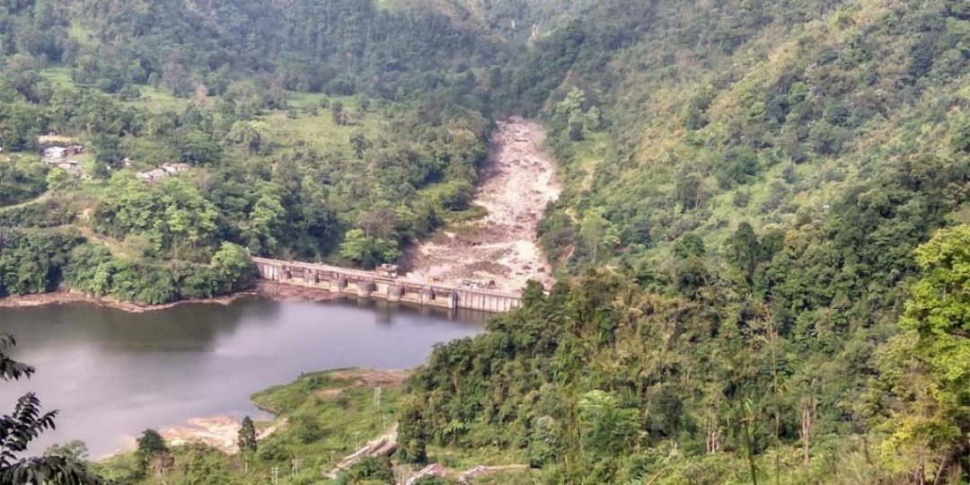
More than a decade after his father Dorjee Khandu ushered in a “dam revolution”, Arunachal Pradesh Chief Minister Pema Khandu has begun scrapping hydro-power projects for non-performance.
The Chief Minister, inaugurating the State’s first community-managed mini hydroelectric project at Dikshi in West Kameng district on September 13, said his government terminated 22 projects worth 3,800 MW while another 46 projects worth 8,000 MW had been served notices.
“These projects have not progressed and people have lost confidence in them. The government is reviewing the hydro-power projects periodically and action will be taken against the power developers found non-performing,” Mr. Khandu said.
Arunachal Pradesh was among 16 States identified during the Atal Bihari Vajpayee government for an ambitious plan in 2003 to make India produce 50,000 MW or hydroelectricity by 2017. This north-eastern State bordering China’s Tibet, accounting for the bulk of the proposed installed capacity was the first off the blocks for the hydro-power “gold rush”.
Agreement spree
A State hydro-power policy drawn up in 2007 saw Arunachal Pradesh sign agreements with both public sector and private sector players. Deals for 142 dams – their capacity ranging from 4.50 MW to 4,000 MW – on virtually all rivers and streams were inked by 2015.
In July 2015, former Congress Chief Minister Nabam Tuki told the State Assembly that Arunachal Pradesh received ₹1,495.6 crore as upfront money and processing fees from agreements signed with 159 companies for projects with installed capacities of 47,000 MW. The upfront money was charged per MW.
Local tribal groups and environmentalists across Arunachal Pradesh and Assam – which fears a massive downstream effect of the proposed dams – stalled most of the mega projects while a few such as the 2,000 MW Subansiri Lower being built by the NHPC has been lying incomplete since 2011.
Over the years, though, the Khandu government has been inclined towards smaller, sustainable hydroelectric projects. “It is time to change our mindset. Clean and green energy can change the economy of the State and the region,” Mr. Khandu said.
Kulsi dam
Meghalaya’s push for the Kulsi multi-purpose dam, declared a National Project, along the Assam-Meghalaya border, has unnerved the residents of 33 villages in Assam.
The project has been in limbo for almost a decade, but a consensus between the Assam and Meghalaya governments has paved the ground for a detailed project report. The dam is proposed on the Kulsi, a river where the endangered Gangetic river dolphins from the Brahmaputra breed, near Ukiam, a village about 75 km west of Guwahati.
The proposed capacity of the Kulsi project has not been specified, but it entails a 62m high concrete dam on the inter-State border. The project is estimated to cost ₹1,460 crore and would affect 15.55 sq km of land in Assam and 5.75 sq km in Meghalaya due to reservoir submergence.
“We cannot let our homes and farmlands be destroyed. The dam will be built over our dead bodies,” said J.R. Marak, the president of a committee involving all the villages.
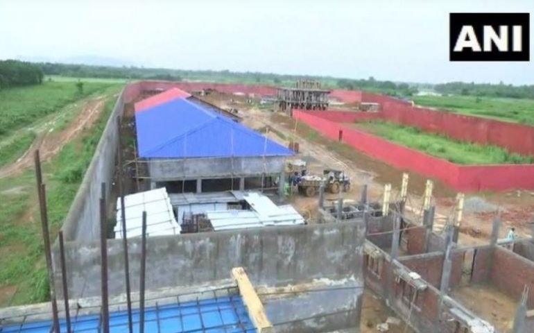
India’s first detention centre is being built in Goalpara district’s Matia.(ANI
In the final list of National Register of Final NRC status: 15 buildings, schools, hospital in India’s first detention centre for those not in Assam NRCCitizens (NRC) published on August 31, more than 19 lakh people were excluded. However, those left out can still apply to the designated Foreigners’ Tribunals within 120 days for their cases to be heard.
The work on India’s first detention centre is progressing at quick pace in Goalpara district’s West Matia area in Assam, weeks after the final National Register of Citizens (NRC) was published, leaving out nearly 1.9 million people.
“The work on this project started in December 2018, our target is to complete it by December 2019. It will cost around Rs 46 crore. Fifteen four-storey buildings are being built — 13 for men, 2 for women,” Junior Engineer (JE) of the detention centre, Rabin Das told ANI.
Some 1.9 million people found themselves out of the final version of the NRC published last month after years of efforts aimed at ending a four-decade movement against illegal immigrants. The Supreme Court-monitored process of updating the NRC for Assam, last compiled 68 years ago, took four years and 55,000 officials poring over 66.4 million documents.
Fifteen four-storey buildings are being built in the detention centre — 13 for men, 2 for women. ( ANI Photo )
Those left out have been given 120 days to approach the Foreigners’ Tribunals for review. Over 200 new tribunals have been set up across the state for this purpose. To accommodate the disenfranchised persons, temporary detention camps have been set up across the state. The one coming up in West Matia area is the country’s first formal detention centre
The detention centre is being constructed over an area of 2,88,000 square feet and will have separate residential facilities for the security personnel and officials. Das also stated that the centre will have separate toilets, hospital, kitchen, dining area, recreational area and a school.
“There will be buildings for officers grade 4 staff. It will have 2 security barracks. The water system will have a capacity of 50,000 litres,” he added, reports ANI.